


ADK - Noonmark et Round mtn
- Gen-Hike

- 21 déc. 2025
- 3 min de lecture
* English version at the bottom.
Keene. Gratuit. Ouvert annuellement. Chiens interdits.
Altitudes respectives de 1084 m et 950 m.
Randonnée 11 km. D+ 1000 m. Niveau : intermédiaire.
Listes : ADK 29ers - Adirondack Hundred Highest
Accès : AMR parking (Ausable Road). Il faut réserver pour ce stationnement du 1er mai au 31 octobre.
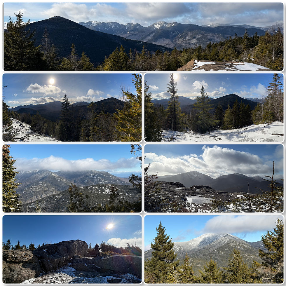
Depuis le parking, montez la route en terre sur environ 500m jusqu'au registre au départ du sentier pour le mont Noonmark. Le sentier commence sur une route privée de gravier jusqu'à une flèche vous indiquant de tourner à droite juste avant une grande grange . À partir de ce point, le sentier débutera une montée progressive sur un ancien chemin forestier, la Old Dix trail. Environ 800 m après le début du sentier, vous arriverez à l'intersection avec Le sentier Henry Stimson pour le mont Noonmark sur la droite. À partir de là, le sentier monte beaucoup plus abruptement à travers une forêt mixte attrayante et magnifique en hiver. À mesure que vous montez, l'approche devient un peu plus exigeante et vous trouverez davantage de dalles rocheuses sous vos pieds et un sentier bordé de cèdres. Cette portion en début d'hiver pourrait s'avérer très glacée, soyez préparés. En chemin, il y a plusieurs points de vue dégagés, avec des vues de plus en plus spectaculaires à chaque point. L'approche finale vers le sommet est assez raide sur des rochers dégagés, et les vues commencent à se déployer notamment Dix, Giant, Sawteeth et la Great Range.
Au delà du sommet de Noonmark, rejoignez le sentier Felix Adler afin d'effectuer une descente assez raide (304 m de perte d'élévation) vers la Old Dix trail. Vous marcherez à flanc de montagne, ce qui sera plus aisé avant d'arriver à l'intersection pour choisir le sentier S. Burns Weston et montrer vers le sommet du mont Round. Un montée exigeante, mais qui sera largement récompensée. Le sommet, un vaste cap rochaux offre des vues similaires à celui de Noonmark, tout aussi magnifiques. Explorez, car ici, le panorama est presqu'à 360°.
Pour compléter la boucle revenez sur vos pas pour reprendre la S Burns Weston trail et effectuer la descente jusqu'à l'Ausable Road. Une descente modérée, dans une forêt de sapins, avec quelques petits ruisseaux à traverser et avec à l'occasion une vue sur l'impressionnant mont Giant.
Bonne découverte !
Pour davantage de photos, cliquez sur le montage ci-bas.
Keene. Free. Open annually. Dogs not allowed.
Respective altitudes of 1084 m and 950 m.
Hike 11 km. Elevation gain 1000 m. Level: intermediate.
Lists: ADK 29ers - Adirondack Hundred Highest
Access: AMR parking (Ausable Road). Reservation required for this parking from May 1 to October 31.
From the parking lot, walk up the dirt road for about 500 meters to the sign marking the start of the trail to Mount Noonmark. The trail begins on a private gravel road until you reach an arrow indicating that you should turn right just before a large barn. From this point, the trail begins a gradual climb on an old forest road, the Old Dix Trail. About 800m after the trailhead, you will come to the intersection with the Henry Stimson Trail to Mount Noonmark on the right. From here, the trail climbs much more steeply through a mixed forest that is attractive and beautiful in winter. As you climb, the approach becomes a little more demanding, and you will find more rocky slabs underfoot and a trail lined with cedar trees. This section can be very icy in early winter, so be prepared. Along the way, there are several clear viewpoints, with increasingly spectacular views at each point. The final approach to the summit is quite steep on exposed rocks, and the views begin to unfold, including Dix, Giant, Sawteeth, and the Great Range.
Beyond the summit of Noonmark, join the Felix Adler Trail for a fairly steep descent (304 m elevation loss) to the Old Dix Trail. You will walk along the mountainside, which will be easier before reaching the intersection where you can choose the S. Burns Weston Trail and head towards the summit of Mount Round. It's a demanding climb, but one that will be richly rewarded. The summit, a vast rocky cape, offers views similar to those from Noonmark, and just as magnificent. Explore, because here, the panorama is almost 360°.
To complete the loop, retrace your steps to the S Burns Weston trail and descend to Ausable Road. It's a moderate descent through a pine forest, with a few small streams to cross and occasional views of the impressive Mount Giant.
Enjoy your hike!


Commentaires